Facilities
NEES Facilities

The NEES Garner Valley Downhole Array (GVDA) is a ground motion research site in a seismically active region in Southern California. It is located in a narrow valley within the Peninsular Ranges Batholith 23 km east of Hemet and 20km southwest of Palm Springs and is just 7 km from the San Jacinto fault and 35 km from the San Andreas fault.
The Wildlife Liquefaction Array (WLA) is a ground motion monitoring and liquefaction research site located at the southern most terminus of the San Andreas Fault system. The WLA field site records numerous earthquakes daily in this seismically active area. WLA is situated in California's Imperial Valley on the west bank of the Alamo River 13 km due north of Brawley, California and 160 km due east of San Diego.
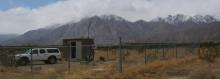
 The Garner Valley Soil-Foundation-Structure Interaction (SFSI) test facility is a medium-scale reconfigurable steel-frame structure founded on a rigid, massive concrete slab on grade. The superstructure is of a size appropriate for testing on one of the NEES shake tables. Shakers can be mounted on the roof for active experiments to complement passive earthquake monitoring.
NEES/USGS Collaborative Sites
In 1993, Kajima Engineering and Construction Corp. and Agbabian Associates established the Borrego Valley Downhole Array (BVDA) near Borrego Springs, in Southern California. The BVDA site consists of borehole and surface instruments that extend east-west 3000m across the Borrego Valley and a remote rock site at the western edge of the valley that includes surface and borehole sensors. The site was installed to provide information about wave propagation across the alluvial basin generated by the Coyote Creek and Clark Faults.

Agbabian Associates installed the Hollister Earthquake Observatory (HEO) in 1991 with funding from the Kajima Engineering and Construction Corp. Kajima Corp donated this array to the University of California, Santa Barbara in January 1998. The site is located in the Salinas Valley about 10 kilometers from the San Andreas fault near the cities of Hollister and Salinas in central California. The ground motion array consists of a vertical array of six accelerometers in Quaternary alluvium and bedrock, and three accelerometers installed at a remote rock station, 3 km to the Northeast.

The Delaney Park Array, with its six 3-component accelerometers at depths from the surface down through the near-surface soil column to 61m, is situated in downtown Anchorage, Alaska. Anchorage sits on top of the great Alaskan subduction zone and has been subjected to large damaging earthquakes in the past. The March 27th, 1964 (Good Friday), magnitude 9.2 great Alaska earthquake shook the ground for more than 4 minutes over a 50,000-square-mile region and caused 131 deaths.

SLA is the downtown Seattle array in conjuction with the University of Washington (UW) and USGS. It was installed Feb ~25th 2012
See the 'Instrumentation' tab below for details of the sensors and data-loggers, including a cross-section diagram of the installation.

The Atwood building is instrumented from the basement to the roof with a total of 32 accelerometer sensors. The building is located just two blocks north of the Delaney Park downhole array. Together the form a richly instrumented system that records local ground motions and building response.
The complete instrumentation details are illustrated by this diagram (courtesy of the USGS).

For more information see the USGS fact sheet:
About 17km south-east of downtown at an elevation of 716m, thats at the edge of the Anchorage lowland alluvial plain, at the base of the Chugach Mountains, a surface and downhole (30ft depth) accelerometer are installed in rock.

This site is located at the 101/280 freeway interchange in San Jose at 37.3393, -121.8520 (approx 31m elevation). A single Granite unit records a surface Episensor and three downhole Hyposensors at 17, 42 and 91m. UCSB assisted in the downhole installations on 3/2/16. The deep hyposensor had a compass and was glass beaded in at 347.2o magnetic, within 1 degree of true-North, and the other two hyposensors were installed with loading-poles, rotated and aligned to true-North.